
2011: One-in-a-Billion ~ 2026-04-27
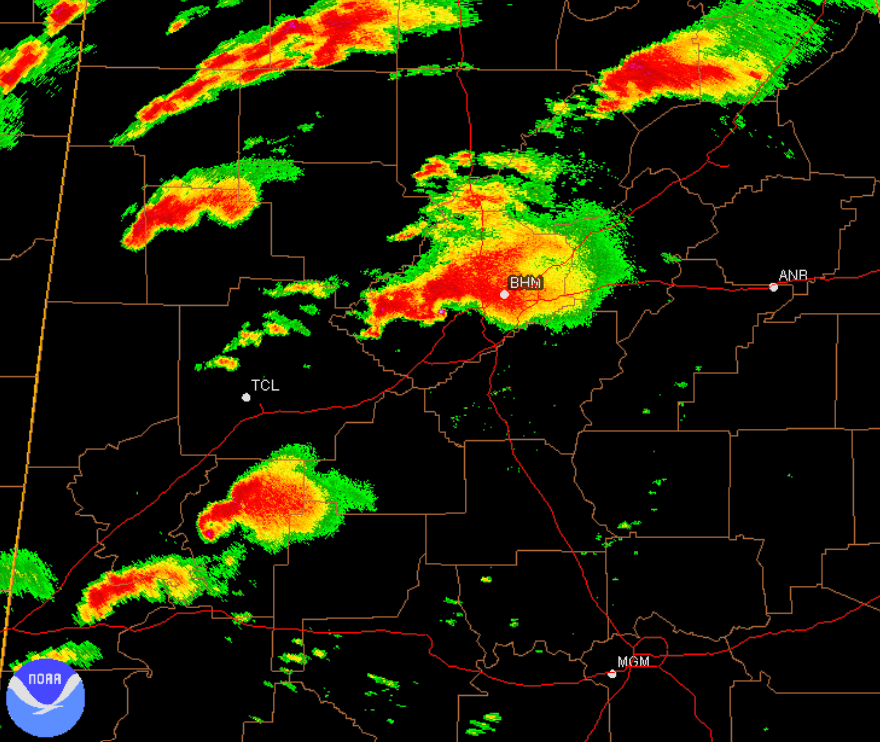
A scan from a weather radar in Birmingham, AL during the peak of the April 27th, 2011 Super Outbreak
It has been 15 years since the worst tornado outbreak of the 21st century ripped across the southeastern United States. For the folks of Alabama and Mississippi, the 2011 Super Outbreak was one of those events where every local had a story; a, “where were you?” type of day.
While the outbreak technically lasted from April 25th through 28th, the 27th was the show-stopper with 224 confirmed tornadoes (15 of which were violent [EF4+] tornadoes), claiming the lives of 316, and injuring at least 3,000. For perspective, you would need to add up the fatalities of the last FIVE full tornado seasons in the United States to eclipse the toll of that single day.
The exceptionality of that event I do not believe gets fully grasped at times. Maybe it's because recency bias is strong in the weather social media sphere, but conceptualizing meteorologically that multiple warm-sector supercell thunderstorms were able to plant strong-to-violent long-tracked tornadoes concurrently seemingly with ease is hard to fathom. So often with high-end severe weather setups, there are still some ‘flies in the ointment’ that derail the potential ceiling from being fully realized. April 27th, 2011 was the one day that was meteorologically flawless on a large scale from a tornado production standpoint.
Looking through many of the notable tornadoes from the day itself, well over a dozen of them could have stood out as the tornado of the day had they been a part of any other outbreak. The dreaded EF5, the mother of all tornado ratings saved for the most extreme of cases, was assigned to FOUR tornadoes. To illustrate the gravity of that, typically a tornado rated a 5 is only seen once every couple years. It is nearly inconceivable to have more than one in day, never mind four. For any tornado nerd, the names Philadelphia (MS, not PA), Hackleburg, Smithville, and Rainsville live in infamy. The most impactful tornado of the day came in the form of a high-end EF4 that would impact the metros of two Alabama cities; Tuscaloosa and Birmingham. 64 people were killed and half of the days’ injuries were at the proverbial hands of that tornado. Additional towns like Cullman, Cordova, and Ringgold would have their legacies forever shaped by the most tragic day in their respective histories… and that’s just the shortlist of the dozens of communities that dot the southeast that were forever changed in the wake of April 27th, 2011.
With respect to the days’ meteorology; what was it that actually made it so exceptional? It’s no secret that you need the big four ingredients of shear, lift, instability, and moisture, but what details allowed it to be a ‘perfect’ tornado outbreak? Starting with the upper levels of the atmosphere, a textbook long-wave trough dug across the continental United States with a strong westerly-orientated jet streak ejecting over the Southeast. The belt of strong flow aloft with diffluence ahead drove extreme rising motion further down and drove rapid cyclogenesis at the surface. That response promotes Warm Air Advection (WAA) with a strengthening southerly Low-Level Jet (LLJ), chock full of moisture from the Gulf. Strong directional wind shear increased with that LLJ response, which allows for storms to rapidly organize their updrafts and rotate efficiently. To support multiple rounds of supercells, multiple confluence bands established themselves in the open warm sector, loosely associated with each of the shortwaves within the main trough. Keeping a lid on things from getting too messy outside of those focused confluence bands was an Elevated Mixed-Layer (EML) transported from the Southwestern US. Thus, only those most focused, well-spaced corridors could see storms initiate.
We can keep digging through the meteorological details, but the bottom line is that every aspect of the ingredients required to support that high-end tornado threat was perfect. From the geometries, to timing, to alignment, to strength and so forth, it was just meteorologically perfect.
Zooming out beyond the 2011 Super Outbreak, that whole tornado season took on a theme of the meteorology simply panning out for tornado production, which was at the detriment for those that found themselves in the path. Less than a month after the Super Outbreak, on May 22nd, the city of Joplin, MO would be subjected to the ultimate worst-case tornado scenario in the 21st century. A rain-wrapped, mile-wide beast roared into the heavily populated city with winds in excess of 200 mph. In just 38 minutes, 158 people died, making the Joplin EF5 the deadliest tornado in 60 years. Two days later, another perfect meteorological setup of the Great Plains variety manifested over Kansas, Texas, Arkansas, and most notably, Oklahoma. Multiple supercells planted strong-to-violent tornadoes, including multiple high-end EF4s and the 6th EF5 of the year.
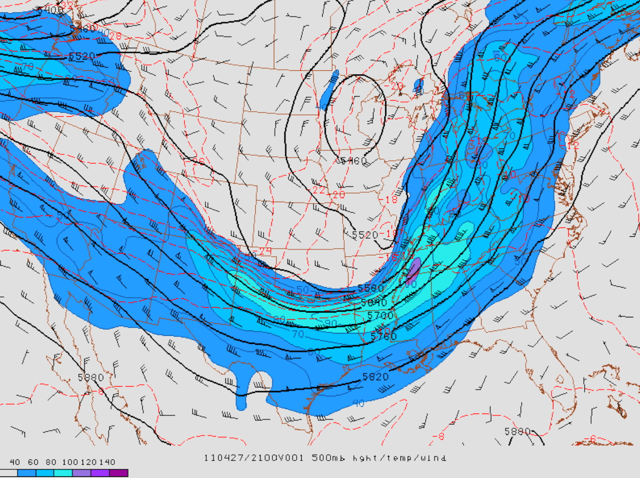
500mb Upper Air Chart from April 27th, 2011 at 21Z (4 PM CDT). Meteorological Perfection
Despite my use of words like, “perfect,” to describe these meteorological events, it is still tough to look back at them knowing the devastation and loss that occurred. In a scientific field like meteorology, a level of isolation from the human side is required to objectively look at these conditions unfolded to yield an incredible result. But at the end of the day, the human stories still exist, something that I’ve become more increasingly aware of as I’ve leaned more and more into the journalistic side of weather. I can marvel at the incredible damage caused by powerful tornadoes, but the concrete slabs I’m analyzing were the literal foundation of someone’s hard-earned work and love manifested into what they called home. Maybe it is that human side breaching at that wall of isolation more and more that is making it tougher for me to be blindly objective in the name of science, but that is a topic for another day.
The more I think about it, the more I doubt we’ll see another tornado season like 2011 in my lifetime. The human toll alone is staggering and a strong outlier compared to even decades prior. Not even a year like 1974, the season containing the original Super Outbreak had the same fatality figure as 2011. To get two theoretically perfect tornado outbreaks for their respective geographic regions in the same year feels like a one-in-a-million type probability. Factor in an actual worst-case tornado scenario that was the Joplin case on top of all that and it starts to feel more like a one-in-a-billion type probability. Maybe in another 25-30 years we’ll see another super outbreak, assuming we keep roughly the same return period. But to get other perfect outbreaks and a generationally worst-case tornado as well in that same year… seems nearly impossible. Thus, it may be safe to say that 2011 will be a year for the ages in the tornado history books.